In Part 4 of this continuing series, author Carol Brzozowski explains the value of 3D subsurface imaging in providing a comprehensive picture to the subsurface site prior to vacuum excavation, underground or directional boring, and other site excavation activities. As author Brzozowski further describes, these advance technologies can provide a much more refined geophysical picture of the site and the results gleaned can be bolster crew safety and boost project savings.
Hitting the Hidden Mark (Part 4) By Carol Brzozowski
The combination of the vacuum and utility locator help get that precise target.
Underground Imaging Technologies (UIT) conducts the indirect measurement of utilities, specializing in 3D subsurface imaging and mapping.
“We match the tools to the conditions,” says Gary Young, vice president of operations and development. “Most people don’t find all of the utilities when they go out. The main reason for that is it takes more than one tool to find everything.”
Crews from Underground Imaging Technologies use many tools and will go over a site multiple times, Young says.
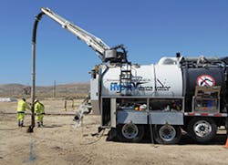
“You hear a lot about ground-penetrating radar, which is a wonderful tool, but there are many soil types that are not friendly to radar,” he says. “If we get out there and test it and see the radar is not working, we’ll do something else. Our goal is to find those utilities with the indirect and geophysical methods so that when someone goes out there with a vacuum excavator, they can find it the first time.”
Hitting the Hidden Mark (Part 4) By Carol Brzozowski
The combination of the vacuum and utility locator help get that precise target. Underground Imaging Technologies (UIT) conducts the indirect measurement of utilities, specializing in 3D subsurface imaging and mapping. “We match the tools to the conditions,” says Gary Young, vice president of operations and development. “Most people don’t find all of the utilities when they go out. The main reason for that is it takes more than one tool to find everything.” Crews from Underground Imaging Technologies use many tools and will go over a site multiple times, Young says. “You hear a lot about ground-penetrating radar, which is a wonderful tool, but there are many soil types that are not friendly to radar,” he says. “If we get out there and test it and see the radar is not working, we’ll do something else. Our goal is to find those utilities with the indirect and geophysical methods so that when someone goes out there with a vacuum excavator, they can find it the first time.” [text_ad] Using 3D utility mapping, “instead of just getting a line drawing of the utility with your vacuum excavation effort, you find out what it is, what it’s made of, how big it is, and then you can actually make a full-scale model of that utility,” Young says. One such technology is UIT’s MetaVision II mapping system. It can be used to cover a lot of ground or in smaller, tighter areas when used in a portable mode by one person, Young says. “This tool operates like a standard pipe and cable locator in passive or inductive mode, but it carries its transmitter around with it and makes contour-able maps of the target signatures.” At a recent job site for the installation of a new water transmission line near Osceola Parkway in Kissimmee, FL, UIT conducted a subsurface utility investigation using several geophysical tools to provide complete coverage of the investigation area with minimal public impact and traffic interruptions. The results from the geophysical investigation and existing utility records allowed UIT and the client to develop a revised test hole program to confirm the locations and types of selected utilities. The findings: Approximately 65% to 70% of utilities shown on client-provided records were mislocated by at least 2 feet at some point along their alignments. Numerous utilities, previously unknown, were mapped by UIT. The utility depth information alleviated potential construction conflicts associated with select targets. The UIT results allowed utilities to be uncovered on the first test hole attempt, reducing the number of dry holes. Actual test hole costs were 50% less than planned. UIT crews had worked on the second stage of the project. “During the first stage, they knew about our capabilities but they decided to go it alone,” says Young. “They took the existing records and a vacuum excavation truck and tried to verify everywhere on the records where they thought their design would set with the existing utilities. And that makes sense until you understand the records are almost never right to some degree. “During the course of the first phase of the project, they struck one of their own water transmission lines, and it cost them $750,000 to fix it,” he adds. “They asked us to come in on the second phase, which is another 1-mile section. Our total billings on the second phase were $170,000. That avoided that big strike, and they could have saved themselves a lot of money in the first place.” [text_ad] When a contractor goes out to a job site with a vacuum truck with the intention of verifying other utilities just going by the existing records, it results in putting in a lot of holes, Young says. “That’s expensive, it’s time-consuming, it’s aggravating to the people around you, it’s bad for the environment,” he says. “There are all kinds of reasons why you really should minimize the number of holes.” UIT uses holes in a well-placed fashion, Young says. On the second phase of the Kissimmee project, Young points out, the engineer working for the water authority had planned on doing 250 test holes on a 1-mile section of road. “After we had done our work, they ended up doing everything to their satisfaction with only 68,” he says. “That savings paid for 50% of UIT’s billings.” Also, being that the area is a huge tourist region in Florida, it minimized the disruption to traffic. Minimizing or avoiding disruption of any kind is the bottom line. “We just finished a bunch of jobs in California for a gas company, and on one of those jobs we found 90 utilities in a 1-mile section of the project that were unknown before we got there,” Young says. Young agrees with others in the industry that the line location and vacuum excavation technologies have become more sophisticated, enabling contractors to provide better solutions to the challenges of the unknown underground. “In the utility industry, we started putting things underground in the 1870s,” says Young. “In those days, some people would try marking underground where that was and keep it for posterity, but most of them didn’t.” If they did mark it, they would mark it from the corner of a building or the curb or a tree, which 50 years from that point wasn’t there anymore, he adds. Many companies, such as gas companies, are becoming fastidious about records when they are constructing new lines, Young says. “They’ll survey it and put really good data back into their records about where that line is,” he says. “Only one time in my career doing this work everything that’s on the records was right and that was with oil refineries up in Calgary in Canada. I’ve never seen that anywhere else.” Essentially, the best way to make a job go well is to do the initial work correctly, Young points out. “Our work is easy from the standpoint that you don’t have to dig in order to find the utilities, at least in that first level,” he says. “I believe you shouldn’t be doing any digging of any kind until you have a good target to go after because it’s safer and saves money. “Vacuum excavation contractors don’t necessarily like to hear that. If they have to search for the utility, it’s more time and holes, but in this world where sustainability starts to matter and costs matter, that doesn’t add up for everyone. You do more efficient projects if you do this stuff in order and do it all right along the way. It’s critical to our work that if do it right, you don’t have to spend so much time and money.” In the next part of this series—a continuation of vacuum excavation applications—Author Brzozowski discusses other subsurface instruments.Using 3D utility mapping, “instead of just getting a line drawing of the utility with your vacuum excavation effort, you find out what it is, what it’s made of, how big it is, and then you can actually make a full-scale model of that utility,” Young says.
One such technology is UIT’s MetaVision II mapping system. It can be used to cover a lot of ground or in smaller, tighter areas when used in a portable mode by one person, Young says.
“This tool operates like a standard pipe and cable locator in passive or inductive mode, but it carries its transmitter around with it and makes contour-able maps of the target signatures.”
At a recent job site for the installation of a new water transmission line near Osceola Parkway in Kissimmee, FL, UIT conducted a subsurface utility investigation using several geophysical tools to provide complete coverage of the investigation area with minimal public impact and traffic interruptions.
The results from the geophysical investigation and existing utility records allowed UIT and the client to develop a revised test hole program to confirm the locations and types of selected utilities.
The findings: Approximately 65% to 70% of utilities shown on client-provided records were mislocated by at least 2 feet at some point along their alignments. Numerous utilities, previously unknown, were mapped by UIT.
The utility depth information alleviated potential construction conflicts associated with select targets. The UIT results allowed utilities to be uncovered on the first test hole attempt, reducing the number of dry holes. Actual test hole costs were 50% less than planned.
UIT crews had worked on the second stage of the project.
“During the first stage, they knew about our capabilities but they decided to go it alone,” says Young. “They took the existing records and a vacuum excavation truck and tried to verify everywhere on the records where they thought their design would set with the existing utilities. And that makes sense until you understand the records are almost never right to some degree.
“During the course of the first phase of the project, they struck one of their own water transmission lines, and it cost them $750,000 to fix it,” he adds. “They asked us to come in on the second phase, which is another 1-mile section. Our total billings on the second phase were $170,000. That avoided that big strike, and they could have saved themselves a lot of money in the first place.”
Hitting the Hidden Mark (Part 4) By Carol Brzozowski
The combination of the vacuum and utility locator help get that precise target. Underground Imaging Technologies (UIT) conducts the indirect measurement of utilities, specializing in 3D subsurface imaging and mapping. “We match the tools to the conditions,” says Gary Young, vice president of operations and development. “Most people don’t find all of the utilities when they go out. The main reason for that is it takes more than one tool to find everything.” Crews from Underground Imaging Technologies use many tools and will go over a site multiple times, Young says. “You hear a lot about ground-penetrating radar, which is a wonderful tool, but there are many soil types that are not friendly to radar,” he says. “If we get out there and test it and see the radar is not working, we’ll do something else. Our goal is to find those utilities with the indirect and geophysical methods so that when someone goes out there with a vacuum excavator, they can find it the first time.” [text_ad] Using 3D utility mapping, “instead of just getting a line drawing of the utility with your vacuum excavation effort, you find out what it is, what it’s made of, how big it is, and then you can actually make a full-scale model of that utility,” Young says. One such technology is UIT’s MetaVision II mapping system. It can be used to cover a lot of ground or in smaller, tighter areas when used in a portable mode by one person, Young says. “This tool operates like a standard pipe and cable locator in passive or inductive mode, but it carries its transmitter around with it and makes contour-able maps of the target signatures.” At a recent job site for the installation of a new water transmission line near Osceola Parkway in Kissimmee, FL, UIT conducted a subsurface utility investigation using several geophysical tools to provide complete coverage of the investigation area with minimal public impact and traffic interruptions. The results from the geophysical investigation and existing utility records allowed UIT and the client to develop a revised test hole program to confirm the locations and types of selected utilities. The findings: Approximately 65% to 70% of utilities shown on client-provided records were mislocated by at least 2 feet at some point along their alignments. Numerous utilities, previously unknown, were mapped by UIT. The utility depth information alleviated potential construction conflicts associated with select targets. The UIT results allowed utilities to be uncovered on the first test hole attempt, reducing the number of dry holes. Actual test hole costs were 50% less than planned. UIT crews had worked on the second stage of the project. “During the first stage, they knew about our capabilities but they decided to go it alone,” says Young. “They took the existing records and a vacuum excavation truck and tried to verify everywhere on the records where they thought their design would set with the existing utilities. And that makes sense until you understand the records are almost never right to some degree. “During the course of the first phase of the project, they struck one of their own water transmission lines, and it cost them $750,000 to fix it,” he adds. “They asked us to come in on the second phase, which is another 1-mile section. Our total billings on the second phase were $170,000. That avoided that big strike, and they could have saved themselves a lot of money in the first place.” [text_ad] When a contractor goes out to a job site with a vacuum truck with the intention of verifying other utilities just going by the existing records, it results in putting in a lot of holes, Young says. “That’s expensive, it’s time-consuming, it’s aggravating to the people around you, it’s bad for the environment,” he says. “There are all kinds of reasons why you really should minimize the number of holes.” UIT uses holes in a well-placed fashion, Young says. On the second phase of the Kissimmee project, Young points out, the engineer working for the water authority had planned on doing 250 test holes on a 1-mile section of road. “After we had done our work, they ended up doing everything to their satisfaction with only 68,” he says. “That savings paid for 50% of UIT’s billings.” Also, being that the area is a huge tourist region in Florida, it minimized the disruption to traffic. Minimizing or avoiding disruption of any kind is the bottom line. “We just finished a bunch of jobs in California for a gas company, and on one of those jobs we found 90 utilities in a 1-mile section of the project that were unknown before we got there,” Young says. Young agrees with others in the industry that the line location and vacuum excavation technologies have become more sophisticated, enabling contractors to provide better solutions to the challenges of the unknown underground. “In the utility industry, we started putting things underground in the 1870s,” says Young. “In those days, some people would try marking underground where that was and keep it for posterity, but most of them didn’t.” If they did mark it, they would mark it from the corner of a building or the curb or a tree, which 50 years from that point wasn’t there anymore, he adds. Many companies, such as gas companies, are becoming fastidious about records when they are constructing new lines, Young says. “They’ll survey it and put really good data back into their records about where that line is,” he says. “Only one time in my career doing this work everything that’s on the records was right and that was with oil refineries up in Calgary in Canada. I’ve never seen that anywhere else.” Essentially, the best way to make a job go well is to do the initial work correctly, Young points out. “Our work is easy from the standpoint that you don’t have to dig in order to find the utilities, at least in that first level,” he says. “I believe you shouldn’t be doing any digging of any kind until you have a good target to go after because it’s safer and saves money. “Vacuum excavation contractors don’t necessarily like to hear that. If they have to search for the utility, it’s more time and holes, but in this world where sustainability starts to matter and costs matter, that doesn’t add up for everyone. You do more efficient projects if you do this stuff in order and do it all right along the way. It’s critical to our work that if do it right, you don’t have to spend so much time and money.” In the next part of this series—a continuation of vacuum excavation applications—Author Brzozowski discusses other subsurface instruments.When a contractor goes out to a job site with a vacuum truck with the intention of verifying other utilities just going by the existing records, it results in putting in a lot of holes, Young says.
“That’s expensive, it’s time-consuming, it’s aggravating to the people around you, it’s bad for the environment,” he says. “There are all kinds of reasons why you really should minimize the number of holes.”
UIT uses holes in a well-placed fashion, Young says.
On the second phase of the Kissimmee project, Young points out, the engineer working for the water authority had planned on doing 250 test holes on a 1-mile section of road.
“After we had done our work, they ended up doing everything to their satisfaction with only 68,” he says. “That savings paid for 50% of UIT’s billings.”
Also, being that the area is a huge tourist region in Florida, it minimized the disruption to traffic. Minimizing or avoiding disruption of any kind is the bottom line.
“We just finished a bunch of jobs in California for a gas company, and on one of those jobs we found 90 utilities in a 1-mile section of the project that were unknown before we got there,” Young says.
Young agrees with others in the industry that the line location and vacuum excavation technologies have become more sophisticated, enabling contractors to provide better solutions to the challenges of the unknown underground.
“In the utility industry, we started putting things underground in the 1870s,” says Young. “In those days, some people would try marking underground where that was and keep it for posterity, but most of them didn’t.”
If they did mark it, they would mark it from the corner of a building or the curb or a tree, which 50 years from that point wasn’t there anymore, he adds.
Many companies, such as gas companies, are becoming fastidious about records when they are constructing new lines, Young says.
“They’ll survey it and put really good data back into their records about where that line is,” he says. “Only one time in my career doing this work everything that’s on the records was right and that was with oil refineries up in Calgary in Canada. I’ve never seen that anywhere else.”
Essentially, the best way to make a job go well is to do the initial work correctly, Young points out.
“Our work is easy from the standpoint that you don’t have to dig in order to find the utilities, at least in that first level,” he says. “I believe you shouldn’t be doing any digging of any kind until you have a good target to go after because it’s safer and saves money.
“Vacuum excavation contractors don’t necessarily like to hear that. If they have to search for the utility, it’s more time and holes, but in this world where sustainability starts to matter and costs matter, that doesn’t add up for everyone. You do more efficient projects if you do this stuff in order and do it all right along the way. It’s critical to our work that if do it right, you don’t have to spend so much time and money.”
In the next part of this series—a continuation of vacuum excavation applications—Author Brzozowski discusses other subsurface instruments.
