There are approximately 100 billion feet, or 20 million miles, of underground utilities in this country, estimates Eric Huber, senior product manager at RIDGID. And every six minutes, a line is damaged. “It’s a huge issue,” he emphasizes. “Backhoes hit natural gas lines and other utilities. It can lead to explosions, water geysers…it happens every day.”
But, it shouldn’t. Contractors should use the One Call system to accurately mark utilities, says Jason Proctor, Ditch Witch product manager for vacuum excavation. “There are a lot of cross-country pipelines; it’s important to call.”
However, because some utilities are excluded from the system, they don’t get marked, leading to safety issues. “On a recent job site, an electric line remained unmarked without the knowledge of the onsite operator,” continues Proctor. “This could significantly jeopardize job site safety.”
Sometimes utility companies fail to register information with One Call. Other times, there are inaccuracies in utility markings on the ground.
“One concern with One Call is the expiration date of the system,” says Proctor. “The system normally is open for a two-week period. If a crew is not able to get out to the job site in time, they not only face safety challenges, but also risk delays in the project.”
Getting a Read on It
There are many challenges to locating underground utilities. Aging infrastructure is one of them. “The older the pipe, the more likely it is to be severed or pinched,” says Cody Mecham, regional sales manager at McLaughlin Underground. The more damage, the more it bleeds off—power and frequency, “It can give a false location if it bleeds.”
Breaks in continuity make readings difficult, as well. So do splices, non-metallic lines, and poor insulation. “You’re trying to send a signal through to make a circuit,” explains Mecham. “If you have poor insulation, it doesn’t make a circuit.”
Breaks in the line are often associated with the age of the line as it degrades. “Plastic line with tracer wire can break,” says Matt Lumbers, product line manager for Subsite Electronics. Locatable tape lasts about six to 12 months, he estimates.
Tracer wires are typically laid with utility lines that aren’t metallic, such as plastic gas line or sewer line. If the line has no metal or is not conductive to electricity, utilities are required to run 10-to 12-gauge wire. If tracer wires aren’t laid, the utilities are unlocatable.
“The only reason is for locating,” emphasizes Mecham. “We rely on installation of tracer wire to locate plastic pipe.”
He says there are still some lines without tracer wire, such as sewer laterals in rural communities. “Typically, they’re PVC, with no metallic component and no tracer wires.”
If tracer wires aren’t laid, the utilities are unlocatable. “There are hundreds of thousands of unlocatable lines,” says Lumbers. “Gas, sewer, water…there are many miles of unlocatable fiber.”
But even when lines do have tracer wire, over the years, those wires get damaged, stretched, or broken. To find unlocatable lines—lines with a high plastic content, fiber, or non-metallic lines—Lumbers says ground-penetrating radar (GPR) is the most common product used. GPR is an electromagnetic imaging technique that can locate items through soil, concrete, ice, and water. In addition to its use in utility mapping, GPR has been employed in geological surveys, archeology, and forensic investigations.
Using the same kind of radio waves as microwave ovens, cell phones, and TV, GPR systems trigger the pulse of energy sent by the antenna. The antenna amplifies it and transmits it into the ground at a specific frequency. Subsurface variations cause the signal to bounce back. A computer records the strength of the signal and the time it took to return. The magnitude and timing of the echo is proportionate to the size and depth of the buried pipe, according to an article by Jeffrey Feigin, Ph.D., Geophysical Survey Systems Inc. (GSSI).
As with any technology, however, GPR has limitations. “One of the challenges is managing expectations in terms of how deep GPR can see on a given job site,” says Peter Masters, applications specialist for GSSI. “Depth penetration is variable, depending on local soil conditions and can even vary within a job site. GPR operators and service providers should be trained well enough to be able to ask questions about and to discuss job site soil conditions so as to provide a reasonable expectation of depth performance.”
The Dirt on Locating Utilities
Soil makes a big difference in accuracy of utility locations, Mecham believes. Dry ground is less conducive. Sandy is difficult; it doesn’t conduct as readily. Rocky soil, iron ore, minerals—all complicate utility detection. Even temperature has an effect.
“Winter ground is frozen, so it’s less conducive,” says Mecham.
Ground makes or breaks a “locate” when using traditional locating equipment, Lumbers states, but it’s possible to “get around the conditions” in order to locate in any soil. “You can add water to dry soil for a better read,” he notes.
However, any dense soil with high moisture content is going to cause difficulty in penetrating deep enough to see when using GPR technology.
GPR is soil-dependent. “Soil conditions are the biggest factor influencing GPR performance and depth penetration,” says Masters. “GPR works best in dry, sandy, loamy soils, while clay soils and additional moisture are more difficult. Basically, the more conductive the soil material, the more the GPR signal attenuates, resulting is less penetration.”
It’s not just soil—salt water and salt-content land can impact a reading. “You can locate over fresh water very well,” says Mecham, “but brackish water and salt water are very difficult because they create distortions.”
While GPR technology continues to improve, Masters says the soil issue has not been resolved. “GPR imagery is vastly improved over the years, just as computing technology is improving. With more powerful electronics, improved GPR signal processing algorithms can run faster and collect and process more data to improve signal-to-noise ratios and increase depth penetration in many instances.”
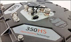
G-551’s 350 Hyper-Stacking antenna
At the forefront of emerging GPR technology is GSSI’s new patented digital utility antenna, the 350 HS or “HyperStacking” antenna. Because standard signal observation methods are slow in some conditions, a technique known as equivalent time sampling allows people to see fast events with slow circuitry by taking multiple samples. By averaging—or stacking—the results of several GPR scan, a radar reflection is captured. Operating at faster speeds than conventional systems in difficult soil conditions, this HyperStacking technique can see deeper targets and is effective in “noisy” conditions, in which a lot of conductors are present: different lines at different depths, common in an urban environment.
HyperStacking, new technology patented by GSSI, uses high-speed sampling to reduce issues such as dynamic range limitations, regulatory compliance issues, sampler core offset errors, and timing errors in order to provide better reads. It has been successful in lower frequency applications such as in dirt, clay, and sand. According to Feigin, “measurement results produced by the technique resolve targets at least 5% deeper and 5% smaller than conventional ETS GPR.”
The HS antenna takes advantage of the latest electronics and signal processing options to produce better resolution and more potential depth range, Masters explains. “By using proprietary real-time sampling techniques to improve the antenna’s receiving capability and averaging results from many individual scans, the HS antenna can better filter out noise, has improved resolution, and can achieve greater depth ranges in good GPR soils.”
GSSI pairs the HS antenna as a stand-alone utility locator on the UtilityScan HS and with the SIR 4000 controller on the UtilityScan Pro series. Feigin writes:
With the commonly used ETS technique, hundreds or even thousands of pulses are transmitted to obtain a full measurement set over the desired time range. However, most of the received energy is discarded and the resultant measurement is inefficient, in terms of noise, relative to the amount of energy transmitted. By contrast, the new technology uses high-speed interpolated sampling, which recovers all or most of the reflected radar information, greatly improving the measurement signal energy with respect to noise. In the past, these techniques have been expensive and far too energy-consuming, but recent advances in integrated circuit technology have enabled the development of low-cost devices that perform at reasonably high speeds while consuming relatively small amounts of power.
Mapping the Noise
Congestion complicates locating. Abandoned lines, cable, tracer wires–all of them add to interference, Lumbers points out.
There are many dormant and abandoned lines underground. “Unused wire is still a problem,” notes Mecham. “They bleed off, giving off a ghost signal that results in a false locate. It creates opportunities for error.”
That’s why, he says, there is value in knowing lines are there, even if they’ve been abandoned. These old lines are important to identify, but a lot of utility maps are not accurate, or simply don’t exist.
“People have bad memories, and there are few indications above ground,” adds Mecham.
In addition, the accuracy of a map depends on how new the service is and if the reference is valid. For example, Lumbers says, if you move a curb 10 feet, the curb as a reference is not valid anymore.
Although, he says the gas industry is getting better about mapping, too many utilities aren’t. One way to work around the absence of information is to follow lines to a point–a pedestal or an ending point that makes sense.
Weather can also play an important role in creating challenges, Proctor adds. “Anything from heavy snows to overgrown grass can obscure, and in some cases erase the utility markings, keeping utilities hidden and creating safety challenges for operators and their crews.”
To find everything in the proposed excavation, first walk and identify above-ground assets, such as a distribution box, cable box, or hydrant, Mecham advises. “Start there to locate, or run to a stopping point like a water tower.”
It is imperative to assess the entire job site to keep track of known and marked utilities, but also to identify potential unmarked utilities, Proctor agrees. He says one of the most important ways operators can locate utilities and keep crews safe is by following a detailed plan for their project.
“Contractor knowledge and experience in partnership with technology, including line locators, keep crews safe, while overcoming challenges of utility detection,” says Proctor.
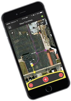
A practical problem may involve finding a utility, flag, or paint, but wanting a more permanent record. Huber says RIDGIDtrax technology allows them to document findings by pairing with a phone or GPS to create maps that are more accurate than hand-drawn maps. “It’s all digital paint,” he says. “Just save and email.”
Part of the process, of the bid, is mapping, Mecham believes. Mapping is important because there aren’t a lot of people entering the trade; knowledge is getting lost as people retire. By taking the guesswork out of locating, more than just one person can do it.
However, as Lumbers points out, there is no regulation to map, so it’s not always done. “Mapping takes time, costs money,” he explains. Therefore, many companies simply don’t do it. “There has to be a change in the way this is viewed within the industry.”
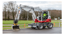
The Ditch Witch FXT65
Technology to the Rescue
There are significant options to overcome these challenges with utility detection and some of the concerns that can lead to unsafe job sites, Proctor insists. “We see a lot of cases where utilities are successfully marked, increasing overall productivity and keeping crews and surroundings safe. As always, there are innovations that can increase the performance of utility detection equipment, such as line locators and vacuum excavators for potholing to help locate utility lines.”
Nozzle improvements to vacuum excavators allow operators to dig more efficiently. The recently released Ditch Witch Prospector Nozzle provides more digging speed to efficiently locate utilities. Beyond improving efficiency, new updates to vacuum excavators continue to keep operators comfortable and in direct control of the equipment.
“With regards to vacuum excavation, a lot of operators see increased value with hydroexcavation and air-excavation capabilities on a variety of projects,” says Proctor.
While these methods have been around the industry in various capacities before, new equipment that combines both methods for utility detection, like Ditch Witch’s FXT Air Series, keeps operators productive and provides versatility to match challenging soil conditions and job site requirements. “We continue to develop new products with the goal of making operators more productive and making their jobs easier and safer,” he adds.
Efficiency, expense, and ease of operation are the critical factors for detection equipment. “Equipment has had to evolve to overcome a lot of challenges,” says Mecham.
Today, most of it has GPS location capabilities integrated into the phone and tablet that allow one person to use it and understand the data. “The software is compatible with global GPS and provides information such as latitude and longitude that allow you to pinpoint the position of a cable. GPS sends an email, locates it on a table, and sends a file,” he says.
Some systems also log what utility it is: water line, fire hydrant, gas, electric.
As with most technology, money dictates the accuracy of the pinpoints. However, GPS requirements now mandate that they pinpoint the depth and location as part of installation. “The materials are getter better and lasting longer,” says Mecham. “That improves accuracy.”
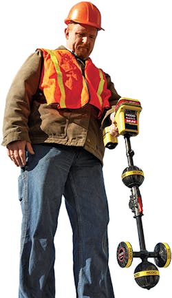
A new G3 utility locator with a directional indicator tells if a line goes straight or turns. “It takes the guesswork out,” surmises Mecham. He says it provides the most accurate peak machine depth estimates in real time–accurate to 30 feet deep, which is important because utilities are putting lines in deeper and deeper (most stop at 15 feet).
Taking the guesswork out and making things easier is more important than ever. Expert readers can interpret signals, but with fewer trained personnel in the industry, making it simpler and easier is important.
“We always try to make it simpler, easier,” indicates Huber. “We make interpretations quick. Results show on the screen, not just through signal strength. There is a compass display. It’s simple and it’s economical with a free download.”
Accuracy is also important. GSSI recently released the LineTrac, an accessory to their UtilityScan systems employing either the DF or HS antennas. LineTrac adds the ability to detect AC power and induced RF energy present in buried utilities. It employs a three-axis 50/60 Hz magnetometer that is used to locate powered and non-powered utilities. It also detects extremely low amplitude AC signals associated with difficult-to-locate utilities.
Technology faces a constant struggle, Lumbers says, because “every day something new goes in the ground.” The more congested the area, the more need there is to understand frequencies and products.
He believes people need training to understand the equipment. For example, if coiled wire is buried three feet deep and phone line two feet, where the two come close is a problem, Lumbers continues. Do you know how to identify that point–or how to fix it? You must be able to check if the antennas line up; if they don’t, you’ll have interference.
“You need to understand what’s available. You need training,” he says.
Subsite Electronics’ UtiliGuard series has three tiers: basic; standard–every frequency and transmitter; and advanced–AIM can measure interference and choose the frequency. It features receiver-transmitter communication and dual output, connecting to two utilities at once. It can also hook to GPS devices if you want to map.
Development
Standard locators are becoming more intuitive, easier to use, and more visual, overcoming the “patchwork system” of software and maps, says Huber. They are also gaining the ability to track multiple lines at once, providing a better understanding of what’s underground. “Lines can bleed or retransmit and change the magnetic field. If you send different frequencies down the line, you can separate the signals,” he says.
Are you using multi- or single frequencies? Lumbers asks. “You should use the same type [of equipment] when verifying that was used to locate.”
There are features that alert you if you “jump off” the target utility by identifying the direction of the signal from the transmitter. “You could be on another utility.”
The challenges vary because each scenario is different, Lumbers says, but he believes that “every player is working at an opportunity to help with damage prevention.”
Damage prevention begins with accuracy. His question is: How accurate is accurate enough? “Accuracy is expensive.”