Excavating a mile-long, horseshoe-shaped canal doesn’t sound like much of a challenge, even when the specifications call for grade accuracies measured in tenths of a foot. But fill the canal with 25 feet of seawater, put a working nuclear plant that depends on the canal for cooling in the center of the horseshoe, add two hurricanes worth of bank erosion, and things begin to get interesting.
They get downright difficult when you add the need to do it all without disturbing the protected sea turtles that find the canal an attractive living environment.
That was the challenge faced by Blue Goose Construction of Fort Pierce, FL. Working with the general contractor, Underwater Engineering Services Inc. of Port St. Lucie, FL, Blue Goose developed some innovative solutions to the project’s unique challenges.
Those solutions, including a unique “underwater” application of a Topcon GPS, enabled the Underwater Engineering Services/Blue Goose team to win the reconstruction contract for the hurricane-damaged cooling water canal at the Florida Power & Light St. Lucie Nuclear Power Plant.
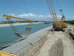
“The canal walls had been seriously eroded by two hurricanes,” says Blue Goose General Manager Larry Tarr. “A decision was made to rebuild the canal and line the walls with mats made of concrete blocks linked with cables.
“The specifications were very tight. We were allowed only a 6-inch tolerance in the finished surface, which meant the real tolerance we had to work to was much smaller than that.”
Of course, before Blue Goose could even begin thinking about holding tight tolerances, its engineers had to figure out how to do the excavation and grading in the first place. Each embankment is 135 feet long with a 3:1 slope, two-thirds of which is under water. The bottom, which has to be flat and level, is 40 feet wide.
“It’s really more like building a road than a canal embankment,” Tarr says. “We have to repair the erosion damage, then place, level, and compact a base of stone and coarse sand mixture before installing the mats. We can’t just dump the fill, because the sand and stone will separate in the water; it has to be placed and compacted one bucket load at a time.
“The traditional approach would have been to build temporary sheet-piling cofferdams and dewater one-half of the canal a section at a time,” Tarr explains, “but, that really isn’t practical. For one thing, the plant is right on the ocean, so dewatering would be a significant challenge all by itself. We also could not do anything with the potential to interrupt the flow of cooling water to the reactor.
“And, of course,” he says, “we had to make sure not to disturb the sea turtles.”
Special Machines
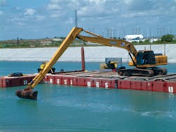
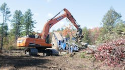
After analyzing the project, Blue Goose determined that the best solution was a combination of shore-based and barge-mounted excavators. The problem there was that the reach necessary to accomplish the job was substantially longer than the capacity of any standard excavator, even in an extended reach configuration.
“The job site is fairly constricted,” says senior project manager John Allen. “The levee top is only 12 to 15 feet wide, so the biggest machine we can use on top of the embankment is a 650 to 750, and even that’s tight. The job requirements are also unusual. Most long-reach excavators are designed to reach and pull the load toward the machine. They typically can only handle their rated load at 60% maximum boom extension.
“We needed to be able to lift a full bucket to maximum extension and then lower it precisely to place the base materials. No standard machine that would fit on the site had that capability, so we decided to have one built.”
Blue Goose commissioned four special long-reach excavators. Working with Nortrax, the company obtained and modified a Hyundai/John Deere 850D, a 450D, and two 240D excavators with extended-reach booms, heavy-lift kits, and special counterweights. Nortrax and Blue Goose worked with Oregon-based Jewell Manufacturing to design and build the extreme-reach booms.
The JD 850D has a reach of 95 feet, the 450D has a reach of 70 feet, and the 240Ds have a reach of 60 feet. All four use the same 2-yard buckets designed by Blue Goose and optimized for underwater use.
“What we have now is a unique capability for underwater grading,” Tarr says. “With these machines, we can take on a whole range of jobs that simply couldn’t be done with conventional excavators. That opens a lot of time- and cost-saving possibilities that never existed before.”
A decision was made to line the canal with protective mats made of concrete blocks.
But obtaining the specialized machines required to do the job was only part of the solution. Performing the underwater grading and placement with the required precision still presented a daunting challenge.
Underwater GPS to the Rescue
“It’s a simple problem, really,” Allen says. “The machine operator can’t see what’s happening at the end of a 90-foot boom that’s under 25 feet of water, but we still have to meet the specs. All we needed was a way to know where the bucket is when it’s below water.
“The answer, of course, is to equip the machine with a high-precision GPS location system that tracks the bucket location and displays it for the operator, along with the actual grade and the specified grade. Sounds simple, and it is-as a concept. We quickly discovered, however, that the system we needed didn’t exist.”
Blue Goose had used laser positioning systems extensively and had also installed a GPS machine control on one of their dozers. But, when the company approached the GPS manufacturer for assistance in meeting the canal project challenge, the answer was, “We can’t do that.”
“There is no “˜can’t’ in this business,” Tarr says, “so we started talking to other GPS suppliers, including Lengemann Corp., a Topcon distributor here in Florida. Jay Waller, the local representative, said that nothing in the standard product line fit our requirement, but that Lengemann and Topcon would be glad to work with us to find a solution.
“That was enough for us. Topcon got the job, and we’ve never looked back.”
As it turned out, the GPS was only part of the solution. The rest was a combination of software and display technology to integrate the system.
“One thing we learned immediately is that GPS does not work underwater,” Allen says. “Each excavator is equipped with a Topcon receiver that precisely locates it to within a few millimeters in three dimensions. The unit has proved to be very rugged and reliable on the job and delivers all the accuracy promised.”
Topcon receivers are ideal for this type of application because they are able to collect data from both the US GPS satellites, and the Russian GLONASS satellites, something most competitive systems can’t do. “Dual Constellation” capability means there is virtually never a time when the receivers are not in contact with satellites of one or both systems, eliminating “no signal” downtime and minimizing potential “blind spots” on the work site.
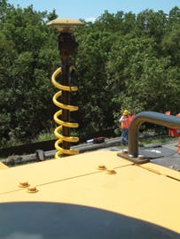
The Topcon receivers use a pair of satellite antennas attached to the counterweight. Waterproof mechanical position sensors are attached to
The system relied on a pair of antennas to sense machine rotation and absolute location.
the boom, the “stick,” and the bucket. The pair of antennas on the counterweight sense machine rotation and absolute location while the position sensors track boom and bucket locations in real time. All signals are integrated by an onboard computer, and the results are displayed for the operator.
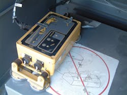
“The software and display technology puts it all together,” Allen says. “Topcon and the software manufacturer worked very closely to produce an integrated system to meet our requirement. Everything is combined in the onboard computer to create a readout that shows the exact location of the bucket to within a few tenths of a foot in real time.
“The computer has a bathemetric survey database showing the actual contours of the embankment that we created from initial survey data, and a model of the finished grade. Those show up as a pair of contour lines on the display along with a side view of the bucket.
“All the operator has to do is watch the display and put the bucket where it’s supposed to be. Sounds easy, but teaching the operators how to use the system was one of the biggest challenges we faced on the whole project.
“Controlling a bucket that’s under 25 feet of water at the end of a 95-foot boom proved to be much easier said than done. And, don’t forget that two of the machines are mounted on barges.”
Training Excavator “Pilots”
Teaching the operators to use the Topcon-based control system was a lot like teaching pilots to fly by instruments. Blue Goose started by letting them practice with the system in a location where they could also see the bucket.
Once the operators had learned to relate the real-world position of the bucket to the in-cab display, Allen covered the windows with opaque
paper and had them run through the training sequence again-this time depending entirely on the display.
The computer had a bathemetric survey database showing the contours of the embankment
“It’s not an easy thing to get used to, and it takes expert operators,” Allen says, “especially when you have been doing it by “˜eyeball’ for many, many years. It’s still stressful for them, particularly on the barge. So, we give them extra breaks to stretch and look at something other than the display. That helps, but it’s still difficult.”
The proof, of course, is in how well the system performs on the job site. After the mats are positioned, divers are brought in to check the installation.
“The exposed slope looks just like a road,” Tarr says. “It’s just perfect, and it’s that way underwater, too. The mats tend to exaggerate any imperfection in the grading or base placement, and so far the job just looks great.
“We started in December 2007,” Tarr adds, “and we’re scheduled to finish grading 1.4 million square feet for the mats by late spring 2009. So far everything is working pretty much exactly as we planned.”
What About the Turtles?
“The divers say it’s like a tropical paradise in the canal, with lots of ocean fish and big loggerhead turtles,” Tarr says. “We work behind a turtle net and have lookouts stationed to shoo them away if they approach.
