Introduction
When it was first invented back in 1960, the laser was described as a “solution looking for a problem.” Laser is an acronym that stands for “light amplified by the stimulated emission of radiation.” It releases a beam of monochromatic light (of one specific wavelength) that is coherent (with all of the light waves acting in unison) and highly concentrated (with a tight directional beam). Industrial laser applications have been more mundane and practical than more fanciful applications in science fiction and James Bond movies, in the form of ray guns. From survey levels to spectroscopy to laser ranging to photochemistry to bar code scanners, lasers are essential to everyday technology. One obviously unexpected application of the laser was in the construction industry.
A more recent development than the laser is, GPS developed by the United States military in the 1980s. This tracking system consists of 24 satellites (one for each hour of the day covering 15 degrees of longitude from pole to pole) in synchronous orbit. Circling the earth twice daily, each broadcasts a unique time signal to the surface where it can be collected by ground antennae. Even traveling at the speed of light there is a measurable time lag between sending and receiving of the time signature. This difference allows a measurement of the distance from the ground point to the satellite. By triangulating the calculated distances from the ground point to multiple satellites, a precise location of the ground point can be determined. GPS was originally intended to provide precise positions of military elements and assets (tanks, planes, ships, etc.) to battlefield command and control. However, by the end of the 1980s, the United States government made both GPS and associated operating frequencies available for civilian use. And so a system designed to move tanks and plane across a battlefield has developed into a system that allows for precise movement of heavy equipment across a construction site.
GPS Systems: How They Work
The automated positioning reporting system (APRS) for earthmoving equipment is a direct application of the general GPS to the construction industry. Using the triangulation technique described, information from several of these high-speed satellite signals can be used to precisely locate the receiver attached to a piece of earthmoving equipment to an accuracy of 30 centimeters (1 foot). Further accuracy, up to a distance of 1 centimeter (0.4 inches), can be achieved using an associated ground system with the APRS.
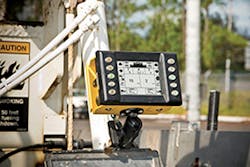
PCS900 Total Station
With this system a fleet operator can integrate the movement and operations of multiple types of earthmoving equipment (excavators, backhoes, front end loaders, graders, dump truck, bull dozers, etc.). These operations are tied to three-dimensional (3D) contour maps (referred to as digital terrain models, or DTMs) of the construction site. The software operates through hardware including sensors attached to the working edge of the equipment (dozer blade, bucket teeth, etc.) and automated computer controls utilizing a machine interface and an operator interface. All of the above are integrated with the software map and hardware controls by means of sensors and other input devices.
An APRS integrates GPS with the machine controls. Traditionally these have been hydraulic cylinders that move and position the blade or shovel. But with an APRS, these have been replaced with electronically controlled servo-type valves. These utilize an induced electrical signal to create a magnetic field that rotates a suspended armature. The armature in turn is connected to a fixed flapper arm that provides the linkage to the rotary spools that generate pressure changes in a closed-loop hydraulic system. This system in turn controls the amount, pressure, and direction of the hydraulic fluid flow.
The control center of the system is the operator interface, which is connected to the hydraulic system via a software control box, which in turn is connected to servo valves via a system of electrical cables. Utilizing the incoming satellite data, these systems reference the site plan’s digital design files (existing andproposed 3D contouring plans) that are stored in a compact-flash memory card, memory stick, or accessed externally from data broadcast by the site’s controlled area network (CAN). These combined information sets, CAN, and GPS, work together to provide the machine’s position and the position of its blade or bucket. Operating in real time, the combined system can accurately place the dozer blade or excavator shovel in the precise location and depth needed to remove dirt and achieve the proposed design grades. The blades and shovel simultaneously move up and down with the forward and backward movement of their machines to ensure the edge is located at the required northing, easting, and elevation (X, Y, and Z coordinates).
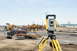
SPS930 Universal Total Station
Machine equipment and the CAN system interface with the GPS by means of built-in sensors. Each GPS sensor consists of an antenna and receiver. Coordinating all of the mobile GPS sensors on each piece of equipment is a stationary GPS sensor combining an antenna with a receiver called the base station. The base station is permanently located over a pre-surveyed reference point such as a third order bench mark (manhole rims, street curbs, and building corners, etc.), or some relative location whose elevation is not exactly known but can be treated as a local datum for the project area. All three elements, mobile sensors, base sensors, and the equipment operator are in continuous communication with each other. The result is a high degree of accuracy at the tip of the bucket and the edge of the blade.
Laser Grading Systems
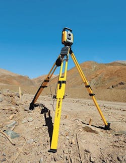
As accurate as it is, GPS has not completely replaced the need for local grading precision, including old fashioned site surveying done with stakes, transits, and target rods. But it is lasers that make for a sophisticated auxiliary system to GPS since they allow for polished shaping or terrain within minimal grade changes. Like GPS, a laser positioning system utilizes a base station. However, this base does not receive information from outside sources; it radiates guiding laser light for the equipment to follow. Specifically, it generates a one-dimensional light beam that is rapidly spun about an axis on top of the tripod that makes up the structural component of the laser base station. The laser itself does not rotate. Instead, a fixed laser shines it light at a rapidly spinning mirror that reflects the light in all directions. These mirrors are either self leveling or manually leveled by traditional bubble level markers.
The broadcast laser light is detected by either a sensor mounted on a pole attached to the equipment, or a handheld surveyor’s pole. The height of the sensor’s “eye” can be raised and lowered until it interacts with the plane of laser light created by the spinning mirror. Upon detection, it will send either a visual signal to the equipment operator in the form of a flashing light or make an audio beep, indicating that the equipment blade is at the proper elevation. These systems allow for simultaneous raising and lowering of the dozer blade as the equipment moves across the site, in effect tracing the elevation or sloped plane created by the laser light. Whenever the blade is off, the deign grade warning information is sent to the operator’s display monitor allowing for accuracy of up to 1 millimeter.
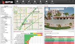
GPS Insight has a focus on customer service, making its vehicle tracking systems easily accessible and user-friendly via a dashboard interface and data integration.
Advantages of Using Laser and/or GPS Equipment Guidance
The advantages of using laser and/or GPS equipment guidance systems are many. With an advanced system, contractors can increase productivity up to 50% compared to traditional methods. This is accomplished by removing expensive reworking of the site and the need for most operational surveying. In doing so, material use is optimized, and the number of actual productive hours during the working day increases.
Increases in overall efficiency allows contractors to deal with any labor shortages by maximizing the use of available personnel. It eliminates the need for physical ground stakes, string lines, and grade checkers. As a results, costs are reduced and contractors can finish projects quicker. Throughout the projects, operators are empowered to check grades and elevations from their cabs, reducing their downtime.
This empowerment is just one aspect of an overall increase in employee satisfaction that comes with laser and/or GPS guidance system usage. Employees are given more responsibility, and can see real-time results of their efforts along with real-time feedback on their progress. These systems eliminate guess work which reduces worker stress. The additional training an operator receives on these systems is a wise investment. And overall job-site safety is enhanced with safety interlocks for park brake, system health, and idle time.
Utilizing laser and/or GPS guidance systems results in significant mechanical upgrades to the equipment itself. Equipment is operated more efficiently, and this increases reliability by reducing wear and tear and while minimizing maintenance requirements. Equipment control configurations are modified to allow foroptimized on-board electronics, easy to use joystick controls, and hydraulic systems. Systems with plug and play connections allow fast conversion from laser grade control systems to GPS and then back to manual control.
Each type of equipment guidance system has it strengths and weaknesses:
- Laser: Works with either open sky or blockage (e.g., over hanging trees) of the open sky. It builds flat, level, or sloping surfaces, but not complex surfaces. It has an effective operating range of about 1,500 feet, and can build surfaces without a 3D model.
- GPS: Works only with an open sky without overhead blockage. It builds flat, sloping, and complex surfaces. It has an effective range measured in miles, but requires a job-site plan loaded onto the machine.
- Sonics: Works in both open sky and blocked sky. It builds roads with string lines (which limit its effective range).
Major Suppliers
With machine control only as good as the model controlling it, Carlson Software has designed two products—Carlson Takeoff and Carlson Construction—specifically to convert paper or digital plans into accurate, efficient models for use with GPS for machine control. While Carlson Takeoff can also be used for precise estimates when bidding for jobs, both 3D surface modeling software solutions are made for site and road construction. Both provide the ability to create 3D surface models and output to all major machine control providers. Jobs are accurately prepared for stakeout or machine control in the field with commands such as draw locate points, create points for entities, divide along entity, and triangulation file utilities. When working with roads, Carlson’s features include the ability to import/create/draw centerlines, vertical profiles, design templates, and cross sections. Carlson’s 3D viewing tools enable users to elevate 2D designs to the 3D model files they need to effectively utilize GPS and machine control.
Caterpillar Inc. is not just a leader in the heavy equipment industry; it is also an innovator in guidance and grading systems. Their AccuGrade Grade Control System increases productivity by up to 40% while reducing site costs. This system is factory integrated, sensor independent, and features a suite of products, which includes cross slope, sonic, laser, GPS, and ATS technology.
The AccuGrade Laser Grade Control System is an earthmoving tool that allows dozer operators to grade and fill with increased accuracy, without the use of traditional stakes or grade checkers. It utilizes machine-mounted components and an off-board laser transmitter to provide precise elevation information on an in-cab display and guide blade positioning. The system allows for a 50% increase in productivity and requires only minimum operator training. Designed for a wide range of construction earthwork applications requiring tight tolerances and high production rates, these systems are often required in project specifications or by general contractors in the construction industry.
Caterpillar’s Accugrade GPS reduces labor requirements and helps operators work on the design plan by accurately cutting, filling, and reducing material costs. It utilizes GPS technology to compare the blade position to a 3D computerized site plan and signals the operator or hydraulic system to raise or lower the blade to achieve the design requirements. It is designed for a wide range of construction earthwork applications, from bulk clearing with high production rates to finish grading with tight tolerances such as complex 3D design for golf course and roads with super elevations. These designs can be directly loaded into the system with a compact flash card.
GPS Insight’s vehicle tracking systems comes with dashboard interface, alerts/reports, landmarks, fuel card tracking, and data integration. Use of this application allows an equipment operator to reduce fuel and labor costs, increase dispatch efficiency for vehicles and other assets, proactively extend the life of vehicles and assets, recover stolen assets faster, and improve billing accuracy based on time onsite and number of visits. It provides real-time maps that visually display and identify construction fleets as well as the current location of individual vehicles or pieces of equipment. Employing a continuous improvement process, GPS Insight takes customer feedback and requests to create new features or iterations of existing features, so that the software does what the customer wants, when they want it, and the way the need to see it.
West Coast Sand and Gravel is an example of a company that has successfully used GPS Insight to achieve these goals, including a reduction in fuel costs by $72,000 per year just by reducing idle time. West Coast Sand and Gravel expressed the need for a more efficient way to relay information from the field back to the office. By using GPS Insight, it improved customer service by providing accurate ETAs to customers and custom forms which are assigned to a Garmin navigation device so that drivers could fill them out at the point of service and send them back to the office in real time. This allowed West Coast to expedite invoices straight to the billing department, identify crew members on the job site for payroll, verify deliveries, and track inventory.
Another satisfied customer is NuBilt Construction & Restoration which uses GPS tracking to ensure quick response time. NuBilt uses the GPS Insight Fleet Tracking Solution to monitor driver behavior and recognize areas for improvement, in order to reduce their fuel expense and improve safety. GPS Insight provides detailed landmark information for NuBilt management to see when employees have arrived and left jobs. “We enter each job into the Landmarks Editor, which will then allow us from this point on to identify this job when an employee either enters or exits or needs to return.”
GPS North America’s Smart Antenna is an equipment tracking system, which automatically tracks engine hours, maintenance requirements, theft and abuse, and real-time usage to measure utilization efficiency. With this equipment, an operator can simultaneously track the movements of his entire fleet. Earthmovingequipment is subject to abuse during the course of normal operations. By recording how long the engine was running each day, and how long it was idling, maintenance needs can be accurately anticipated. This well planned preventative maintenance can be a major cost saver—avoiding costly breakdowns and repair efforts—for any equipment operator.
GPS Trackit offers a full package of affordable, money-saving GPS tracking hardware and software solutions for construction fleet vehicles, heavy equipment, portable assets (water tanks, mobile generators, etc.), and office trailers. It allows for real-time tracking and location on demand as well as theft protection via their GeoFence breach alerts and stolen asset tracking. It provides reports and alerts for ignition and power take off, fuel consumption, billing records, work site compliance, and scheduled maintenance. Two-way communication between foremen and crew via the dedicated website optimized for display on mobile tablets. Their Satellite GPS Solution allows for tracking in urban, rural, and remote locations. Crew management is enhanced by scheduling, equipment allocation, compliance, parking landmarks, emergency alerts, and time sheet logging capabilities.
Hemisphere global navigation satellite system (GNSS) offers a variety of antennas (positioning, heading, and differential) as well as receivers and OEM boards. All are designed for durability in harsh environments (commercial and residential construction, open pit mines, landfill operations, etc.). These satellite positioning systems can be tailored to a particular task or work environment.
InSite Sitework’s Field General software combined with InSite SiteWork allows point data to be prepared for layout with traditional data collectors and positioning equipment (traditional two person total station, robotic total station, or GPS). It allows a programmer to fine tune machine control models and export them to any brand of machine control system. It also allows for easy formulation of staking files including offset staking of curbs, building footprints, road centerlines, and right of ways. Verification of work done allows for real-time measurement of work in progress. The Field General Office module can export surface models to products like Caterpillar Accugrade, Leica PowerGrade 3D, Topcon’s 3DMC2, and Trimble’s Grade Control machine control systems. This is done by loading its triangulated surface file into an on-board machine. Once installed, the GPS unit supplies the X and Y (northing and easting) coordinates, and the triangulated surface provides the target elevation data.
INTEQ/Geoshack provides machine control technology, service, and support. Their machine control technology allows for the implementation of onboard control systems for a wide variety of earthmoving equipment. On the software end, their GIS provides data displays to the equipment operator and the home office.For general construction, they supply lasers, total stations, optical instruments, and sonic based ground controls.
Leica Geosystems Inc. provides GNSS/GIS/GPS surveying systems, data collectors, and reference networks. For surveying there is the new Leica GPS900, which uses Leica Geosystems’ GPS technology. The system consists of a Leica RX900c Color Controller and a Leica ATX900 GG GNSS Antenna mounted on the all-on-the-pole GPS900 RTK rover, which allows for one-person stakeout and topographic tasks. It is lightweight and easy to use with icon-based, graphical onboard software which can be easily using the ¼ VGA touch screen. AutoCAD integration is provided by its “Direct.dxf” functionality, so data can be read directly from the instrument in dxf-format and read into AutoCAD.
MOBA Mobile Automation AG provides machine controls that are both sophisticated and ruggedly built for harsh conditions. This is accomplished by protecting against vibrations, dust, heat, and moisture with a special sealing technology. Ease of use is provided by displays with well designed, but simply laid out, menu navigation. Their bulldozer systems include the two dimension leveling system, the GS-506, and a 3D system, the Moba 3D-Matic. Each comes with a high level of flexibility in terms of choice of sensors and fields of application. The provide two 2D systems for excavators, the simple and inexpensive Xsite EASY and the more comprehensive Xsite PRO. The Xsite PRO comes with a high resolution 8.4 inch touch screen display and can be upgraded to 3D. For direct 3D use, there is Xsite PRO ADVANCED for complex projects.
In addition to multiple software applications, Teletrac provides GPS tracking hardware. It integrates their Fleet Director software to report real-time locations and activity via actionable GPS data. The Prism TM470 allows fleet owners to stay connected to their fleet’s every move in real time including information such as their precise locations and engine statuses. If a vehicle is currently out of range, a complete history—including vehicle speed, direction, and ignition on/off status—is stored and automatically sent to the Fleet Director software package once the vehicle returns to a coverage area. The Prism TM470 features a built-in J-Bus 1708 and 1939 CAN decoder for insight into vehicle performance, such as fault codes or hard braking events. It also supports Teletrac’s OBD-II interface, allowing the reporting of valuable data, such as fuel use and miles driven. The more rugged Prism TM470R is for a wide range of heavy equipment and machinery assets, including earthmovers, graders, backhoes, forklifts, compressors, large generators, and HVAC systems.
Terrain Modeling Services provides a data preparation service for 3D machine control, layout, and quantity takeoffs. These services include the preparation of digital 3D surfaces from AutoCAD files and/or construction plans for machine control and grade checking. They also supply line work (e.g., curbs, utilities lines, etc.) and point files for job-site stake out while computing earthwork quantities for bidding and billing purposes.
Topcon Positioning Systems provides a wide range of surveying and equipment guidance systems. For site grading, their 3DMC² utilizes inertial technology and GPS + GLONASS coverage. Operational smoothness and accuracy are ensured by a 100-Hz blade position update rate and matching 100-Hz hydraulic update rate. For mass excavation, their 3D excavator systems utilize their Sitelink 3D software system for data exchange and support, which is designed to allow for swappable components for excavators, wheel loaders, scrapers, dozers, and motor graders, even changing buckets on the fly.
Trimble Navigation Geomatics & Engineering is a major player in the GNSS industry, providing GNSS survey solutions tailored to particular situations. Their Trimble R10 GNSS System is capable of surveying hard-to-reach points with built-in firmware that automatically compensates for to 15 degrees of pole tilt providing RTK level precision. The R10 comes with Trimble’s advanced technologies such as Trimble HD-GNSS, Trimble SurePoint, Trimble CenterPoint RTX, and Trimble xFill, integrated into the system. Their Trimble R6 GNSS system combines GNSS technology with the scalability that allows the system to grow and expand its capabilities as business and project needs change.