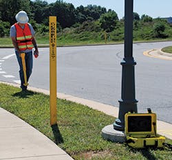
Possibly the most dangerous objects are those that are not simply inactive, but were left behind (to rot and disappear like grass cuttings and leaves) when new infrastructure was installed. In conversations about buried obstacles, the most mentioned problem may be the presence of underground infrastructure that is not recorded, or recorded inaccurately, usually from several or many years ago when the urge to put everything underground was not so strong as today. Most municipalities and other local authorities are certainly doing their best to remedy that lack of information. “Put it underground and forget it” may be a philosophy of yesterday that is causing too many problems today. The good news, however, is that just about anything underground can be detected by today’s instruments and the better news is that contractors and utilities are improving at recording the true details of their digging and placing.
Some of the pipes, wires, and buried treasure under the site where you must work are not live or explosive, but many of them are dangerous to you, your employees, and anybody nearby. HDD crews come across some of the most complicated networks of underground obstacles because much of their work is located in places where other technologies have been used (and sometimes rejected, once installed). What could happen? Injuries and lost lives should head our list of possible costs. Susan Harmon, P.E., Certified Safety Professional, who works for The Charles Machine Works (possibly better known to you by its Ditch Witch equipment) is a national expert in underground detection and procedures. She adds several items to a list of painful costs for underground utility damage; apart from injuries and deaths she mentions litigation costs, job delays, citations, fines, increased insurance premiums, and a bruised reputation. “None of these costs are exclusive to horizontal directional drilling,” notes Harmon, “but they can definitely be avoided. It is critical that operators and crews understand the practices that they can follow to operate safely and successfully.” Call 811 has had an encouraging history of accidents prevented; it is not a substitute for the actual location of underground obstacles, but it is a great start. It should be done 48 hours before you intend to start your digging or drilling.
Some people don’t bother to call Call 811. Common Ground Alliance has many individuals, companies, groups, and sponsors and is recognized as a leading association committed to saving lives and preventing damage to underground infrastructure. Many people, possibly most people, won’t bother to call 811 to find underground utilities if they are “only” planting a tree, planting shrubs, putting in a pole for a basketball hoop, building a deck, putting up a fence, or making a patio. Utilities can be anywhere underground; I have a shallow one that follows the fence between my property and my neighbor’s. That is a great place for planting flower beds. Finding out if you are going to dig into them is not done best with a spade or small digging machine. But before we laugh at those unwise homeowners who don’t take the proper steps before digging, let’s think on the statistic that about three-quarters of all underground damage events had a locate ticket called in! In those cases, the excavator (amateur and professional) knew what was down there, but didn’t take sensible precautions to avoid it.
The Right Procedures
Hitting gas or electric lines scares us more than anything, because they can bring the noises and flashes of death or serious injury. “Striking an electric line presents hazards to the drill operator, the tracker, and the surrounding people,” observes Harmon, in reference to horizontal directional drilling. “Because it is not always evident that an electric line has been hit by an HDD, drills should have an electric strike indicator [ESID] which detects when a strike has occurred. Some ESID systems can potentially detect proximity to an electric line under certain conditions, but this is not the intended use of the ESID and must not be used or relied upon for this purpose.”
If there is a strike, an alarm is sounded; if you hear it you can assume that a strike has already happened. Some drill manufacturers provide a bonded operator station to help protect the operator, but electrically insulated boots and gloves are still required as a precaution when the operator is working on electrical job sites (and that means within 10 feet of a buried electrical line).
Other workers in the crew should realize that they are in danger as well as the operator. Touching the machine, for example, could be deadly when there is an electric strike. “When the drilling is in progress,” advises Harmon, “no one should be near the machine or anything connected to it, such as mud systems, while drilling is in progress. No one should be adding pipe, leaning on the machine etc., while it is drilling. If a strike occurs, the machine and anything connected to it will be electrified and a person standing one the ground and touching the machine will provide a path for electricity to flow to the ground, resulting in a shock. The ground around the machine will be electrified, so that walking will provide a voltage difference between the feet, which will also allow electricity to flow, resulting in a shock.”
With an electric strike, then, those near the machine should not try to walk away.
Key to a successful underground project, in the planning stage when you are finding out what obstacles are in the way of your equipment for the new work (whether it is horizontal directional drilling or excavation of any size), is using the right equipment. There is not just one way of detecting the underground utilities, and most manufacturers of locating instruments will tell you which products are suitable or inappropriate for your particular work. You may need more than one type. If you are using a directional drill, for example, the machine should be big enough to complete the pilot hole and pullback, but not too big for the available space! Tools for the downhole work and fluid additives must fit the soil conditions, and all the necessary support and safety equipment (which could include accessories) should be where it’s wanted.
On any locating task there are equipment qualities you should demand. The detecting device should be accurate! Yes, technologically wonderful instruments can disagree, depending on what they are asked to detect. The conditions for the soil underground can cause variations in the efficiency of instruments. To compare two locating instruments, a good way to determine the more accurate is to test them at a place where you already know the position of underground cable or pipe. See which device is more accurate.
If your own crews are going to use the utility locators, try to get models that are simple to operate. “Sophisticated does not need to be complicated,” comments Guillermo Warley, head of product development at Schonstedt Instruments, a company that has been successful in this business for more than 50 years. “Locators haven’t changed much in recent years, but having too many buttons and menus unnecessarily complicates some locators. New users should be able to learn the basics of operating the equipment quickly. Simplicity applies to more than just the user interface; battery replacement, storage, carrying etc. should all be easy to do.”
In other words, we could say that using a utility locator should not be a burdensome, complicated business, because it does not need to be. “The locator should be sturdy, but durability is not always a given in locators,” adds Warley. “We at Schonstedt have learned a lot of lessons from the magnetic locator side of our business. Both land surveyors and the guys that look for unexploded ordnance work (such as mines, and Schonstedt has found many of them over the years) work under rough conditions and push theequipment to the limits. Look for a strong material and solid construction. A good indication of the sturdiness of the locator may be inferred from how many years of warranty the manufacturer offers.”
What Could Be an Underground Hazard?
Electric lines and gas pipes are always the most obvious hazards, and rightly so because the damage they can cause is terrible—to people and property. We should not, however, forget about water and sewer lines, which can be as harmful as anything else in their own way. Can you locate a water line? Yes. Can you detect an obstacle that is not gas or electric? Yes. Ditch Witch, for example, offers the 150 beacon, which works with many Ditch Witch locators to help you trace water, sewer, and drain lines. The target could be metallic pipe or non-metallic pipe or conduit, and the 150 beacon lets you trace a path or locate blockages. With frequencies of 512 Hz to 33 kHz, these beacons have been successful for underground construction professionals in transmitting accurate location and depth information. The short range water/sewer beacons can trace pipes at ranges of up to 12 feet through non-metallic pipe or 6 feet through cast iron pipe. The long-range water/sewer beacons offer ranges of up to 30 feet through non-metallic pipe or 20 feet through cast-iron pipe. Through plastic pipe, the short range conduit beacons can trace pipes at ranges up to 12 feet, while the long-range conduit beacons have ranges up to 30 feet.
The San Jose-Santa Clara Regional Wastewater Facility (RWF) is in the South San Francisco Bay. This facility was built nearly 60 years ago and cleans an average of 110 million gallons of wastewater per day. It serves eight cities with 1.4 million residents and 17,000 main sewer connections. The facility is the largest advanced wastewater treatment facility in the western United States. Its 2,600-acre site includes a 175-acre wastewater operations area, a 750-acre sludge drying area, and an 850-acre former salt production pond.
“Knowing to a high degree of accuracy what is buried is absolutely critical to any of the many improvement and repair projects being done on the site,” observes Tom Hayes, Geosystems Manager. “In the past, the utility could depend on veteran staff, some of whom had worked at the site for several decades, to say what was buried where even when there was no written documentation in the files. Many of those veterans have retired and current employees may have little or no knowledge of the location of buried utilities.”
Hayes explains that the utility did not have a documents management system, with as-built drawings scattered in huge racks of hundreds of drawings. That makes it difficult and time-consuming to find what you need. “Given that it is difficult or impossible to pinpoint specific buried utility locations when viewing most of our as-built drawings, and the cost overruns associated with poorly or undocumented buried utilities, we decided we needed a different approach to managing them,” he says.
RWF implemented subsurface utilities engineering (SUE) practices, establishing its own Subsurface Utilities Management Program. Their goal was to document at least 90% of the utilities on the entire site to avoid problems for their large capital investment program. They decided to document the utilities both on drawing and in a GIS database. RWF adopted the ASCE (American Society of Civil Engineers) ASCE C-I 38-02, Standard Guidelines for the Collection and Depiction of Existing Subsurface Utility Data, which helped them quantify how good the locational/positional accuracy of each of its buried utilities is. The goal of the standards is to “allow the project owner, engineer, and constructor to develop strategies to reduce risk or, at a minimum, to allocate risk due to existing subsurface utilities in a defined manner.” Each utility in the GIS is assigned a Quality Level according to ASCE 38-02.
The SUE practices of the wastewater facility included the implementation of a specific “Buried Utilities Management Toolbox Strategy” in order to better locate utilities. The toolbox includes a GIS system; use of a multiple utility, designating technologies in addition to available drawings; ground penetrating radar; electromagnetic locators; magnetic locators; and a laser rangefinder. This toolbox collection of instruments and devices accentuates the reality that you cannot depend on any single piece of equipment or data source when you need to locate a buried utility or a multitude of buried utilities.
“We found in our situation that the most effective strategy is to use a variety of tools and technologies, and develop an approach where they can all work together,” says Hayes. “The core of our strategy is the GIS, and all the buried utilities information is stored in this database.”
Ground penetrating radar (GPR), mentioned above, was most helpful at this large site. Two ruggedized GPRs, manufactured by Geophysical Survey Systems, Inc. (GSSI), are used and Hayes says they are a game changer. “Despite the fact that we are located on the edge of San Francisco Bay Estuary with a high water table and clay soils, our GPR can function in approximately 70% of our service area. In some locations we can see anything up to six feet deep, while in other locations we can see only utilities less than one foot deep. Despite these limitations, the use of GPR is absolutely critical to the success of our SUE program.”
Does this work? Here are some comments from Peter Masters, an Application Specialist for GSSI, a global leader in ground penetrating radar, on the RWF project. “Before the implementation of the Buried Utilities Management Toolbox Strategy, a new headworks facility was constructed at a total cost of about $90 million. RWF had to spend $1 million locating poorly documented or undocumented buried utilities, mostly by potholing at hundreds of locations. Potholing, actually digging holes to locate utilities, may be the most accurate way of identifying buried utilities, but it is by far the costliest method. On average, a single pothole can cost from $2,000 to $5,000. In addition to the cost of potholing, the poorly or undocumented buried utilities resulted in a six-month project delay. If the toolbox strategy had been in place for this project, estimated savings would have been approximately $400,000. And there would have been less than three weeks of project delays. The project was completed millions of dollars over budget and more than a year late. This experience led directly to the development by RWF of the Subsurface Utilities Management program with its crucial toolbox strategy.”
Everyday Detecting of Buried Utilities
The locators that detect underground utilities which are most seen by us are those that resemble wands and are carried by workers who walk along with them like beachcombers with metal detectors walking the beach at low tide to find treasures thrown up by the ocean. For many contractors, the question is whether to have their own crews do the detecting or hire an outside professional. That is a decision that depends on your particular circumstances. Neither method (in-house or outsource) is necessarily better than the other if it is done correctly. Cost is a practical consideration, but so is efficiency. Something that is sometimes overlooked is that your crews should know what the different colors of markers indicate! Make sure your employees know what red, yellow, and blue mean…or why bother to be careful?
A couple of years ago, in the alley behind my office, a young man with a large excavator was about to plunge the blade into the ground decorated with colorful markers. I asked him if he knew what yellow and red marks meant.
“They mean that somebody has been here with one of this sticks to see what’s below,” he replied.
That was the sum total of his knowledge. (He did wait to dip his blade in the ground until he understood the markers—and he’s still alive.)
An advance in technique that must have made a huge difference to detecting underground utilities is the addition of wheels to the locating device. Even if the locator is lightweight, it will only seem so for a short part of the day. Carrying anything all day will be heavy work. Among wheeled locators that have earned success in recent years has been the Noggin SmartChariot from Sensors & Software. This device is usually hauled behind a vehicle and has proven especially valuable for checking subsurface conditions like those of bridges and pavement structures. It offers a high range of resolution, with GPR in 250, 500, and 1000 MHz units and has an integrated odometer for the collection of data at equal intervals along the survey line. The sensors have a suspension ride just above the ground surface. Pavement evaluations are not strictly utility hunting but locating devices like the Noggin SmartChariot can save money and time on the same principles. The evaluations usually involve expensive, labor-intensive, and destructive coring of the road structure to get estimates of the asphalt and granular thicknesses. Typically, cores are collected at set intervals to cover the length of the road; there are often too may cores specified. A GPR survey before coring gives us a solid basis for determining how many cores are really necessary and where they should be placed. If the GPR survey shows that the granular and asphalt boundaries show minimal spatial variation, only one core may be required. If there are large variations in the subsurface, cores can be positioned where there is thick, thin, or anomalous layering to understand the subsurface in detail.
The MALA Easy Locator HDR is one of the most successful wheeled GPR locators. The original Easy Locator, when it entered the market decades ago, could claim to have changed the entire approach to GPR utility locating. Today the machine looks almost identical as the original, but “the core technology is completely reworked and new, with patents pending,” asserts Bernth Johansson, head of research and development at MALA.
“With a performance that truly speaks for itself in both data quality and speed, today’s Easy Locator delivers results with much more detail, and with more than a 20% increase in depth of penetration in normal soil. We have found unique ways to drastically improve the dynamic range and signal bandwidth of the system. In plain English, we have developed a system that penetrates deeper while, at the same time, delivers higher resolution in the shallow regions. It is like having a system with several antennas built into one.”It detects metallic and non-metallic utilities, offers more than 14 hours of continuous operating time with an operating speed more than 15 mph. The machine’s scan rate can be more than 1,024 scans per second, and it has single button operation.
Another brand name that has been in the locating business for a long time (since 1921 for related challenges) is McLaughlin. The Verifier G2 is perhaps their best-known product today, especially as the transmitter is completely waterproof and now offers a 3-year warranty, including water damage. It’s a locator that is easy to use. The Peak Mode of the receiver will pinpoint locations for accurate excavation and depth calculations, while the Null Mode will let you do fast tracing of lines with its clear guiding arrows. The Verifier G2 offers four frequencies to give you the most suitable for the type of service, distance, and grounding conditions of your locate. (The four frequencies are: 512 Hz, 9.5 kHz, 38 kHz, and 80 kHz.) A feature called Depth Readout and Current Measurement Index (CMI) helps the user to identify the target line in congested areas (and also, by report, helps build operator confidence). Depth capacity (as shown in test conditions) is 30 feet for extreme depth and noise conditions, 0–16 feet for normal conditions. Another interesting feature of today’s Verifier G2 is the new data storage and time stamp feature that includes a built-in clock to record date, time, depth reading, and current measurement value of your work in detection. The unit can store up to 400 depth readings and may be downloaded to any PC.
There are a lot of questions, aren’t there? If you’re just starting into the detection of underground utilities you’ll need to do some research. Your dealer should be able to help, but you may also find it useful to study some of the excellent websites (for the companies mentioned in this article and for others, because there are many good manufacturers) for features and benefits. You can be sure that the instrumentation you need is available, but it may not be just one product or one technique. Price will always be a consideration, but not the only one. What you need is the right equipment for your situations, or the external source who has the right equipment and efficiency to do what needs to be done at your sites.
